Roseville, CA, has transformed into a major hub within Placer County, drawing buyers who want access to top-tier amenities without sacrificing connectivity. Whether you are commuting to an office in downtown Sacramento or running errands near the Galleria, understanding the local infrastructure is a crucial step in your property search.
The city offers a highly developed network of highways, local bus routes, and extensive trail systems to keep residents moving. Evaluating these transportation options early in your home search ensures you choose a neighborhood that aligns with your daily routine and long-term goals in 2026.
Driving in Roseville: Major Roadways and Traffic Patterns
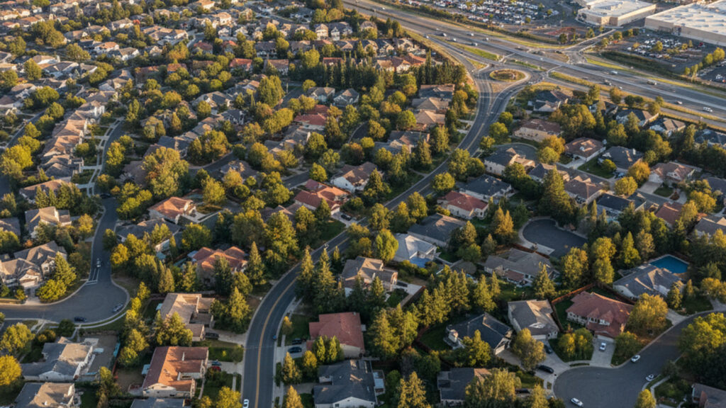
Roseville features a highly developed, car-centric infrastructure that makes driving the most common way to navigate the region. The city layout relies heavily on major highways and wide arterial roads for both local errands and regional travel.
While certain commercial pockets offer pedestrian access, owning a vehicle remains a practical necessity for most daily tasks in the suburban sectors. Buyers looking at master-planned communities in West Roseville will find that a car is essential for reaching grocery stores, schools, and entertainment venues efficiently.
Navigating Interstate 80 and State Route 65
Interstate 80 serves as the primary east-west corridor, connecting Roseville directly to Sacramento in one direction and the Sierra Nevada in the other. State Route 65 acts as the essential north-south artery, linking the city to neighboring communities like Lincoln and Rocklin.
Morning and evening rush hours reliably produce traffic congestion where these two major freeways intersect. Recent interchange improvements have helped smooth traffic flow, but commuters should still expect bottlenecks during peak travel times.
Commuting to Downtown Sacramento
The typical off-peak driving time between Roseville and downtown Sacramento sits between 25 and 30 minutes. However, during the peak morning and evening commute windows, travel durations routinely stretch to 45 minutes or more.
Utilizing carpool lanes and regional rideshare options can significantly trim these overall travel times. Buyers planning to work in the city center should test this drive during rush hour to understand exactly how it will impact their daily routine.
Public Transportation Infrastructure
For those who prefer to leave the car at home, Roseville provides a robust public transit network that serves as a viable alternative for both local and regional travel. The system coordinates smoothly through centralized transit centers and strategically placed park-and-ride lots.
The regional transit system offers excellent reliability, though coverage favors the denser commercial and historic districts over the sprawling western subdivisions. Commuters utilizing these services often find that the cost savings and reduced driving stress easily outweigh the structured departure schedules.
Roseville Transit and Placer County Transit Services
Roseville Transit operates a network of local fixed-route buses alongside the Arrow on-demand service, which provides flexible neighborhood pickups. Placer County Transit expands this reach, connecting residents to nearby Auburn, Lincoln, and Rocklin.
Dedicated commuter bus services cater specifically to downtown Sacramento workers, offering direct routes during peak hours. In 2026, single commuter fares run approximately $3.25 for residents and $4.50 for non-residents, with seamless payment available through the regional Connect Card integration.
Rail Connections via the Capitol Corridor Amtrak Station
The historic train station located at 201 Pacific Street anchors downtown Roseville and provides essential regional rail connections. The Capitol Corridor service operates from this hub, maintaining 15 weekday round trips as of 2026.
These routes traverse from the Sierra foothills down through Sacramento, eventually reaching San Jose and the broader Bay Area. Rail transport holds massive appeal for long-distance commuters seeking a comfortable, productive ride while bypassing heavy highway congestion.
Active Transportation: Biking and Walkability
The city demonstrates a strong commitment to non-motorized transport, maintaining over 173 miles of bike lanes and 400 miles of paved sidewalks. This extensive infrastructure supports an active lifestyle and provides dedicated routes between residential subdivisions and local parks.
While a completely car-free lifestyle is challenging in the sprawling suburban zones, it is highly feasible in specific, dense neighborhoods. Buyers prioritizing active transportation can easily find properties that allow them to cycle or walk to major retail centers and dining options.
Paved Bike Paths and The Miner’s Ravine Trail
Roseville features 45 miles of off-street trails, with the Miner’s Ravine Trail standing out as a premier route for cyclists and pedestrians. This dedicated path allows for continuous travel across the city away from heavy vehicle traffic.
Local transit buses are equipped with bike racks, making multi-modal commutes a practical choice for residents working further afield. These trail systems add immense recreational and practical value to the residential properties located along their access points.
Pedestrian Infrastructure Near Westfield Galleria
The commercial hub surrounding the Westfield Galleria and the neighboring Fountains shopping center offers an exceptionally walkable environment. Residents in this district enjoy a high density of retail spaces, restaurants, and entertainment venues accessible entirely on foot.
This clustered pedestrian experience contrasts sharply with the master-planned suburban sectors of West Roseville, where homes are spread out and car-dependent. Buyers who value leaving their car parked on the weekends often target townhomes and condos immediately adjacent to this retail corridor.
The Intersection of Transit and Local Real Estate
Access to transportation networks directly influences housing options, property values, and buyer demand throughout Roseville. Homes offering immediate access to Interstate 80 or State Route 65 consistently experience shorter days on the market.
Properties that successfully balance quiet suburban living with rapid commuter connectivity command a distinct premium in today’s market. Buyers are willing to pay more for locations that minimize their daily driving time while still providing spacious lot sizes.
Property Types and Median Prices in Connected Neighborhoods
The housing stock near major transit corridors ranges from traditional single-family homes to modern, attached townhouses. In 2026, median home prices in these highly accessible Roseville neighborhoods range from approximately $615,000 to $690,000.
Buyers considering attached properties near transit hubs must also factor monthly HOA fees into their overall carrying costs. Ultimately, these price points reflect the high value local residents place on a streamlined, predictable daily commute.
Frequently Asked Questions
How long is the commute from Roseville to Sacramento?
The drive from Roseville to downtown Sacramento typically takes 25 to 30 minutes during off-peak hours. During the morning and evening rush hours, commuters should expect the trip to take 45 minutes or more. Utilizing commuter buses or carpool lanes on Interstate 80 can help reduce this travel time.
Does BART go to Roseville?
No, the Bay Area Rapid Transit system does not extend into Roseville or Placer County. Residents looking for regional rail travel can instead use the Capitol Corridor Amtrak service located at 201 Pacific Street. This train provides direct connections to Sacramento and the broader Bay Area.
How do you pay for Roseville Transit?
Riders can pay for Roseville Transit using exact cash on the bus or by utilizing the regional Connect Card system. The Connect Card allows users to load funds online and tap to pay across multiple regional transit networks. Single commuter fares cost approximately $3.25 for residents and $4.50 for non-residents in 2026.
Is Roseville a walkable city?
Walkability in Roseville depends entirely on the specific neighborhood you choose to call home. Commercial districts like the Galleria and downtown offer excellent pedestrian infrastructure with close proximity to retail and dining. However, the sprawling residential communities in West Roseville are highly car-dependent and require a vehicle for most errands.